What if a farmer could detect crop stress before it’s even visible? Or a lender could assess farm risk without stepping into the field? This isn’t a future scenario. It is already unfolding across India, powered by satellite monitoring.
Agriculture remains the backbone of the Indian economy, contributing nearly 18% to the country’s GDP and employing over 45% of the workforce. Yet, for decades, decision-making across the sector, whether on farms or in financial institutions, has largely depended on fragmented information, manual verification, and uncertainty.
Satellite technology is now changing that equation.
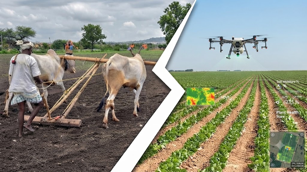
From Observation to Intelligence: The Shift in Farming
Traditionally, farmers have relied on experience, intuition, and local advisories to make decisions. While effective to an extent, this approach often leaves little room for precision, especially in a time when climate variability and input costs are rising.
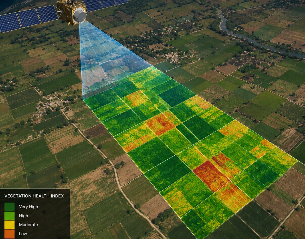
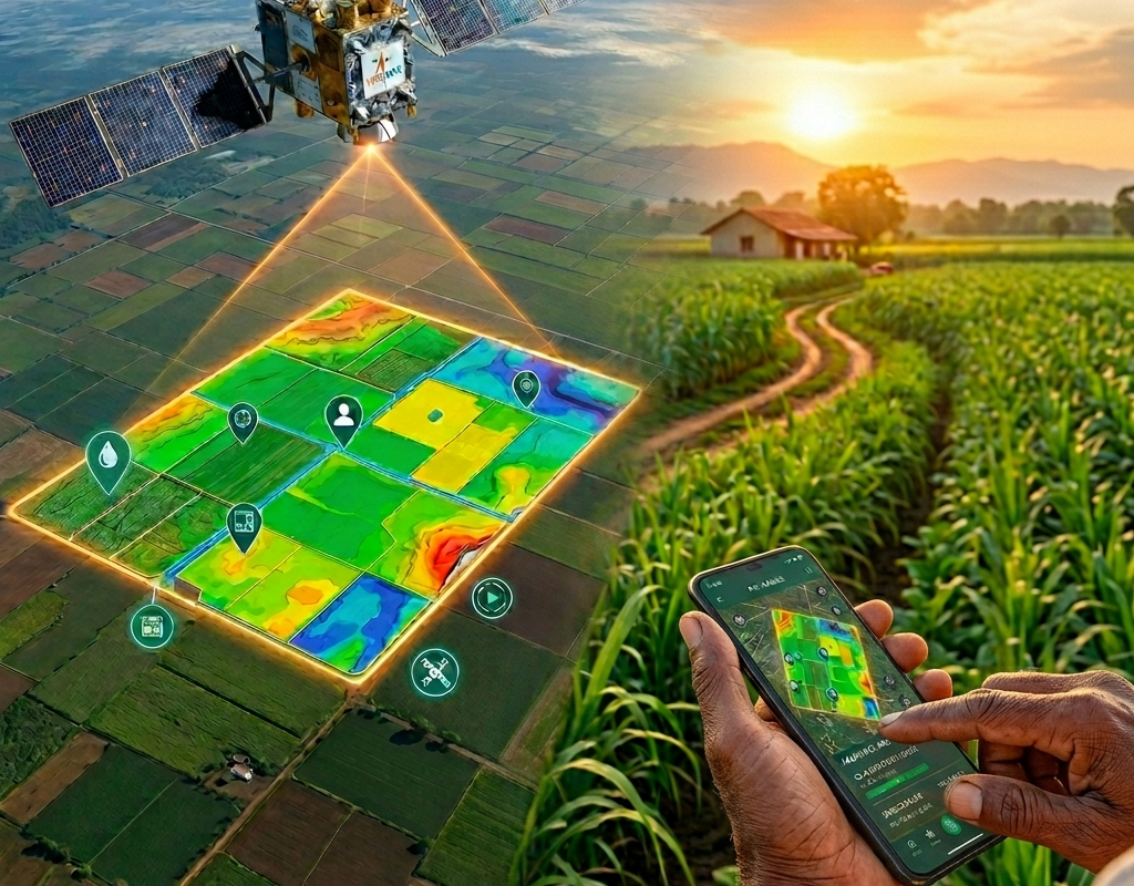
Satellite monitoring introduces a new layer of intelligence by enabling real-time and historical insights into farmland. Using remote sensing technologies, it captures data on crop health, soil moisture, vegetation patterns, and weather behaviour.
Globally, this shift is gaining momentum. The global precision agriculture market, valued at approximately USD 9.5–11 billion in 2024-2025, is projected to reach over USD 20–22 billion by 2030–2034, growing at a CAGR of roughly 8.5%–15%.
For the Indian market, the precision agriculture market is rapidly expanding, with estimates placing its value around ~USD 1.1 billion to USD 2.5 billion in 2025. The market is driven by rising adoption of AI-IoT integration, drones, and GPS-guided machinery to improve yield and sustainability.
Making Better Decisions at the Farm Level
So, what does this mean for farmers on the ground?
Satellite monitoring allows them to move from reactive to proactive decision-making. Instead of identifying issues after visible damage, they can act early, often before losses occur.
For instance, satellite imagery can detect subtle variations in crop health using vegetation indices such as NDVI. These signals help identify stress caused by pests, nutrient deficiencies, or water imbalance. With this information, farmers can take targeted corrective measures rather than applying inputs uniformly across the field.
Similarly, insights into soil moisture enable more efficient irrigation planning, which is critical in a country where water resources are increasingly under pressure. Adopting precision agriculture practices is proven to improve productivity and reduce input costs. For farmers, this directly translates into improved profitability and resource efficiency.
Reimagining Risk in Agricultural Finance
While the benefits at the farm level are significant, the impact of satellite monitoring becomes even more transformative when viewed through the lens of finance.
Agricultural lending has traditionally been considered high-risk due to factors such as unpredictable weather, a lack of reliable farm-level data, and reliance on manual verification processes. This has resulted in limited access to formal credit for many farmers.
India’s agricultural credit supply has grown impressively, from ₹13.3 lakh crore in FY 2021 to ₹20.7 lakh crore in FY 2024 (Economic Survey 2023–24). Yet, despite these gains, millions of smallholder farmers still face persistent challenges.
Satellite monitoring addresses one of the core issues in agri finance: lack of visibility.
By providing verified land data, accurate crop identification, and real-time monitoring of crop conditions, it enables financial institutions to assess risk more objectively. Lenders no longer have to rely solely on declarations or outdated records; they can make decisions based on live, data-backed insights.
AgriBhumi: Translating Data into Action
However, satellite data in its raw form can be complex and difficult to interpret. The real impact lies in converting this data into meaningful, usable insights. This is where agribazaar’s AgriBhumi platform comes into play.
AgriBhumi is designed to simplify geospatial intelligence by transforming satellite data into actionable information for farmers, agri-businesses, and financial institutions. It creates a comprehensive digital profile of farmland by integrating multiple data layers.
Through AgriBhumi, users can access geo-tagged farm boundaries, monitor crop health across growth stages, analyse soil and crop history, and evaluate land productivity. The platform is already operational across 13+ states in India, with 3 Cr+ ha of farmland mapped, enabling large-scale adoption of data-driven agriculture. One of its key strengths is its integration with farmer profiling systems, enabling more structured and reliable assessments.
Connecting Technology with Finance
The true potential of satellite monitoring is realised when it connects seamlessly with financial services.
Within the StarAgri ecosystem, agribazaar’s AgriBhumi works in tandem with Agriwise, the group’s NBFC arm focused on agricultural financing.
This integration creates a powerful feedback loop:
- Satellite data improves farm visibility
- Improved visibility strengthens credit assessment
- Stronger assessment enables faster loan approvals
For farmers, this means quicker access to credit with fewer hurdles. For lenders, it means reduced risk and improved portfolio quality.
By combining data intelligence with financial services, agribazaar and Agriwise are helping build a more inclusive and efficient credit ecosystem, one where facts, not assumptions, drive decisions.

Conclusion: A New Foundation for Indian Agriculture
As agriculture faces increasing pressure from climate change, resource constraints, and market volatility, the need for precision and transparency is becoming more critical than ever.
Satellite monitoring, supported by platforms like AgriBhumi and integrated with financial solutions like Agriwise, is laying the foundation for this new approach. It is not just about improving yields or speeding up loans. It is about fundamentally transforming decision-making across the agricultural value chain.
In the future of agriculture, the most powerful tool may not be in the field but in the data that helps us understand it better.
Disclaimer
The content published on this blog is provided solely for informational and educational purposes and is not intended as professional or legal advice. While we strive to ensure the accuracy and reliability of the information presented, agribazaar make no representations or warranties of any kind, express or implied, about the completeness, accuracy, suitability, or availability with respect to the blog content or the information, products, services, or related graphics contained in the blog for any purpose. Any reliance you place on such information is therefore strictly at your own risk. Readers are encouraged to consult qualified agricultural experts, agronomists, or relevant professionals before making any decisions based on the information provided herein. agribazaar, its authors, contributors, and affiliates shall not be held liable for any loss or damage, including without limitation, indirect or consequential loss or damage, or any loss or damage whatsoever arising from reliance on information contained in this blog. Through this blog, you may be able to link to other websites that are not under the control of agribazaar. We have no control over the nature, content, and availability of those sites and inclusion of any links does not necessarily imply a recommendation or endorsement of the views expressed within them. We reserve the right to modify, update, or remove blog content at any time without prior notice.